
A geographic information system, or GIS, is an information technology system that allows for the storage, manipulation, analysis, and display of information that has a geographic component, also called geospatial data.
GIS allows for the visualization of multiple layers of geographic data to provide an easy means to present and interpret it. Complex spatial analysis and queries can also be performed within and among data in a GIS to locate new trends and expose relationships.

How is GIS used?
GIS is used to make maps that communicate, perform analysis, share information, and solve complex problems worldwide. GIS can be used to identify problems, monitor change, understand trends, and perform forecasting.
Who uses GIS?
Hundreds of thousands of organizations in virtually every field use GIS. GIS has a broad global community. Professions utilizing GIS include education, health, public safety, sustainability, telecommunications, transportation, natural resources, government, and many more.
Geospatial data
Data types with a spatial component are called geospatial data, which exists in one of two formats, vector or raster.
Vector data
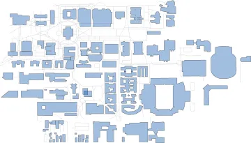
Vector data are datasets with explicit coordinates and are represented as points, lines, or polygon features. Point data is often referred to as simply "location data" because they represents a location in space. Features that have a length or distance, such as rivers and roads, are referred to as lines, while features with an area are called polygons. Polygons are used to represent regions such as parcels, cities, forests, states, or countries.
Raster data
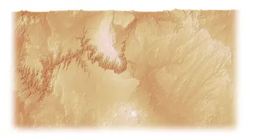
Rasters, or coverages, are images whose edges have been given a geographic location. While vector data is explicit, because rasters are composed of pixels, they represent average values within the area covered by the pixel. Rasters are often used in a GIS to show elevation, satellite images, or paper maps that have been scanned into a digital format and given geographic extents.
For more information about what GIS is, who uses it, and all of the things you can do with it, check out some of the links below: